NOAA Aircraft Operations Center (AOC) Flight Level Data

browse graphic
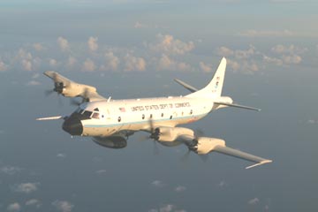
Image of Lockheed WP-3D Orion aircraft (source: NOAA AOC).
NOAA AOC WP-3D Research Flight Data is digital data set DSI-6420, archived at the National Climatic Data Center (NCDC). This data set is meteorological data gathered by Lockheed WP-3D Orion aircraft, operated by the NOAA Aircraft Operations Center (AOC) at MacDill AFB, Florida. Data is provided by the Science and Engineering Division of AOC to the National Climatic Data Center (NCDC). The WP-3D aircraft perform many projects throughout the year. Examples of these projects would be hurricane research, atmospheric chemistry, thunderstorm investigations, and winter weather missions. Each of these projects consists of a series of individual flights. For instance, during hurricane projects, the P-3 may fly numerous flights through different tropical cyclones. For each archived project, there are multiple directories consisting of individual flights. The data in these flight directories contain the actual raw meteorological parameters obtained from sensors located in different positions on the aircraft. The data is initially written to a digital data tape on the aircraft and then later converted to a file for faster processing and archiving. Each flight folder also contains a scanned image of the actual flight manifest, the navigation log, and the mission observation logs. The flight-level data file contains measurements acquired in one second intervals. The following is a generalized list of these measured parameters: Time, GPS position data, inertial data, radar altimeter measurements, liquid water, total temperature, dewpoint temperature, attack pressure, slip pressure, differential attack and slip pressures, and static and dynamic pressure. Depending on the needs of each individual project, other sources of data will be added or subtracted from this list. As of publication this record consists of 5 projects: 1) NOAA-42 Aircraft-N42RF during the 2003 Hurricane season, the Tamdar project, and a wind calibration flight. 2) NOAA-43 Aircraft-N43RF-2003 Sar Pod, Hurricane, and Extratropical Season as well as the SFMR test flight missions. 3) NOAA-49 Aircraft-N49RF 2004 Winter Storms Experiment. 4) NOAA-43 Name Experiment 2004. 5) NOAA-49 Aircraft N49RF Hurricane Season 2004.
  • Cite as: NOAA Aircraft Operations Center ([year of data]): NOAA AOC Flight Level Data [indicate dataset name and subset used]. NOAA National Climatic Data Center. [access date].
  • NCEI DSI 6420_02
  • gov.noaa.ncdc:C00581
Search Data
Distribution Formats
  • ASCII Text
  • netCDF (Version: 3)
  • Native Binary
  • XML
Ordering InstructionsContact NCEI for other distribution options and instructions.
DistributorNOAA National Centers for Environmental Information
ncei.info@noaa.gov
Dataset Point of Contact Customer Engagement Branch
NOAA National Centers for Environmental Information
1-828-271-4800
ncei.orders@noaa.gov
Time Period1989-09-15 to Present
Spatial Bounding Box Coordinates
N: 80.0
S: -10.0
E: -30.0
W: -180.0
Spatial Coverage Map
Dataset Information
General Documentation
Publication Dates
    No administrative dates available
Data Presentation Form Digital table - digital representation of facts or figures systematically displayed, especially in columns
Dataset Progress StatusOngoing - data is continually being updated
Data Update Frequency Quarterly
PurposeThis dataset is intended to provide a detailed understanding of atmospheric processes in storms for researchers.
Dataset Citation
  • Cite as: NOAA Aircraft Operations Center ([year of data]): NOAA AOC Flight Level Data [indicate dataset name and subset used]. NOAA National Climatic Data Center. [access date].
Cited Authors
  • DOC/NOAA/OMAO/AOC > Aircraft Operations Center, Office of Marine and Aviation Operations, NOAA, U.S. Department of Commerce
Originators
  • DOC/NOAA/OMAO/AOC > Aircraft Operations Center, Office of Marine and Aviation Operations, NOAA, U.S. Department of Commerce
Publishers
  • DOC/NOAA/NESDIS/NCEI > National Centers for Environmental Information, NESDIS, NOAA, U.S. Department of Commerce
  • DOC/NOAA/NESDIS/NCDC > National Climatic Data Center, NESDIS, NOAA, U.S. Department of Commerce
Theme keywordsGlobal Change Master Directory (GCMD) Science Keywords
  • Earth Science > Atmosphere > Atmospheric Pressure > Atmospheric Pressure Measurements
  • Earth Science > Atmosphere > Atmospheric Pressure > Differential Pressure
  • Earth Science > Atmosphere > Atmospheric Temperature > Surface Temperature > Air Temperature
  • Earth Science > Atmosphere > Clouds > Cloud Microphysics > Cloud Liquid Water/Ice
  • Earth Science > Human Dimensions > Natural Hazards > Tropical Cyclones > Hurricanes
  • Earth Science > Human Dimensions > Natural Hazards > Severe Storms
  • Earth Science > Atmosphere > Atmospheric Pressure > Pressure Thickness
  • Earth Science > Atmosphere > Atmospheric Temperature > Upper Air Temperature
  • Earth Science > Atmosphere > Atmospheric Water Vapor > Water Vapor Indicators > Humidity
  • Earth Science > Atmosphere > Atmospheric Water Vapor > Water Vapor Profiles
  • Earth Science > Atmosphere > Atmospheric Winds > Upper Level Winds > Flight Level Winds
  • Earth Science > Atmosphere > Atmospheric Winds > Wind Dynamics > Vertical Wind Velocity/Speed
  • Earth Science > Atmosphere > Atmospheric Winds > Wind Profiles
  • Earth Science > Atmosphere > Clouds > Cloud Microphysics > Cloud Optical Depth/Thickness
  • Earth Science > Atmosphere > Precipitation > Precipitation Amount
  • Earth Science > Atmosphere > Precipitation > Precipitation Rate
  • Earth Science > Oceans > Ocean Temperature > Sea Surface Temperature
  • Earth Science > Spectral/Engineering > Microwave Wavelengths > Brightness Temperatures
  • Earth Science > Spectral/Engineering > Platform Characteristics > Airspeed/Ground Speed
  • Earth Science > Spectral/Engineering > Platform Characteristics > Attitude Characteristics
  • Earth Science > Human Dimensions > Natural Hazards > Tropical Cyclones > Cyclones
  • Earth Science > Human Dimensions > Natural Hazards > Tropical Cyclones > Typhoons
Data Center keywordsGlobal Change Master Directory (GCMD) Data Center Keywords
  • DOC/NOAA/NESDIS/NCDC > National Climatic Data Center, NESDIS, NOAA, U.S. Department of Commerce
  • DOC/NOAA/NESDIS/NCEI > National Centers for Environmental Information, NESDIS, NOAA, U.S. Department of Commerce
Platform keywordsGlobal Change Master Directory (GCMD) Platform Keywords
  • Aircraft > WP-3D ORION > Lockheed WP-3D Orion
Instrument keywordsGlobal Change Master Directory (GCMD) Instrument Keywords
  • Earth Remote Sensing Instruments > Passive Remote Sensing > Profilers/Sounders > Dropwindsondes
  • Earth Remote Sensing Instruments > Passive Remote Sensing > Profilers/Sounders > Dropsondes
  • Earth Remote Sensing Instruments > Passive Remote Sensing > Profilers/Sounders > Radio Sounders > GPS Sondes
  • In Situ/Laboratory Instruments > Profilers/Sounders > XBT > Expendable Bathythermographs
  • In Situ/Laboratory Instruments > Profilers/Sounders > XCP > Expendable Current Profiler
  • In Situ/Laboratory Instruments > Chemical Meters/Analyzers > PMS 2D-C PROBE > Particle Measuring Systems 2D-C Probe
  • In Situ/Laboratory Instruments > Chemical Meters/Analyzers > PMS 2D-P PROBE > Particle Measuring Systems 2D-P Probe
  • In Situ/Laboratory Instruments > Chemical Meters/Analyzers > PMS 2D-S PROBE > Particle Measuring Systems 2D-S Probe
  • In Situ/Laboratory Instruments > Chemical Meters/Analyzers > PMS > Particle Measuring System
  • Earth Remote Sensing Instruments > Active Remote Sensing > Profilers/Sounders > Radar Sounders > ELDORA > Electra Doppler Radar
  • Earth Remote Sensing Instruments > Active Remote Sensing > Imaging Radars > CBR > C-BAND RADAR
  • Earth Remote Sensing Instruments > Passive Remote Sensing > Spectrometers/Radiometers > Radiometers > MR > Microwave Radiometer
  • Earth Remote Sensing Instruments > Passive Remote Sensing > Spectrometers/Radiometers > Radiometers > Step Frequency Radiometers
  • Earth Remote Sensing Instruments > Passive Remote Sensing > Spectrometers/Radiometers > Radiometers > MFRSR > Multifilter Rotating Shadowband Radiometer and Broadband Pyranometer
  • Earth Remote Sensing Instruments > Active Remote Sensing > Scatterometers > POLSCAT > Polarimetric Ku-Band Scatterometer
  • Earth Remote Sensing Instruments > Active Remote Sensing > Scatterometers > C-SCAT > C-Band Scatterometer
  • IR CO2 ANALYZER > Infrared Carbon Dioxide Analyzer
  • Earth Remote Sensing Instruments > Passive Remote Sensing > Thermal/Radiation Detectors > Pyranometers
  • Earth Remote Sensing Instruments > Passive Remote Sensing > Thermal/Radiation Detectors > Pyrgeometers
  • Anemometers
  • In Situ/Laboratory Instruments > Temperature/Humidity Sensors > Temperature Sensors
  • In Situ/Laboratory Instruments > Pressure/Height Meters > Pressure Sensors
  • In Situ/Laboratory Instruments > Spectrometers/Radiometers
  • In Situ/Laboratory Instruments > Profilers/Sounders > CTD > Conductivity, Temperature, Depth
Place keywordsGlobal Change Master Directory (GCMD) Location Keywords
  • Ocean > Atlantic Ocean > North Atlantic Ocean
  • Ocean > Pacific Ocean > North Pacific Ocean
  • Continent > North America
Stratum keywordsGlobal Change Master Directory (GCMD) Location Keywords
  • Vertical Location > Troposphere
  • Vertical Location > Sea Surface
Use Constraints
  • Cite as: NOAA Aircraft Operations Center ([year of data]): NOAA AOC Flight Level Data [indicate dataset name and subset used]. NOAA National Climatic Data Center. [access date].
  • Use liability: NOAA and NCEI cannot provide any warranty as to the accuracy, reliability, or completeness of furnished data. Users assume responsibility to determine the usability of these data. The user is responsible for the results of any application of this data for other than its intended purpose.
Access Constraints
  • Distribution liability: NOAA and NCEI make no warranty, expressed or implied, regarding these data, nor does the fact of distribution constitute such a warranty. NOAA and NCEI cannot assume liability for any damages caused by any errors or omissions in these data. If appropriate, NCEI can only certify that the data it distributes are an authentic copy of the records that were accepted for inclusion in the NCEI archives.
Fees
  • In most cases, electronic downloads of the data are free. However, fees may apply for custom orders, data certifications, copies of analog materials, and data distribution on physical media.
Lineage information for: repository
Processing Steps
  • 2015-04-22T00:00:00 - NOAA created the National Centers for Environmental Information (NCEI) by merging NOAA's National Climatic Data Center (NCDC), National Geophysical Data Center (NGDC), and National Oceanographic Data Center (NODC), including the National Coastal Data Development Center (NCDDC), per the Consolidated and Further Continuing Appropriations Act, 2015, Public Law 113-235. NCEI launched publicly on April 22, 2015.
Last Modified: 2023-06-23
For questions about the information on this page, please email: ncei.info@noaa.gov