NOAA JPSS Microwave Integrated Retrieval System (MIRS) Advanced Technology Microwave Sounder (ATMS) Precipitation and Surface Products from NDE

MIRS-IMG-NDE

browse graphic
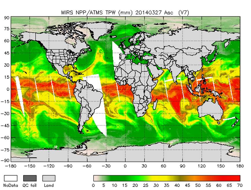
MIRS ATMS global ascending total precipitable water (TPW) from March 27, 2014. Image courtesy of NOAA OSPO.
This dataset contains two-dimensional precipitation and surface products from the JPSS Microwave Integrated Retrieval System (MIRS) using sensor data from the Advanced Technology Microwave Sounder (ATMS) onboard the Suomi National Polar-orbiting Partnership (S-NPP) satellite. ATMS is a cross-track scanner with 22 channels in spectral bands from 23 GHz through 183 GHz. MIRS was developed by the NOAA/NESDIS Center for Satellite Application and Research (STAR) and is produced operationally at the NOAA/NESDIS Office of Satellite and Product Operations (OSPO). The precipitation and surface products file, or imaging (IMG) products file, contains total precipitable water (TPW), skin temperature, emissivity by channel, rain rate, cloud liquid water (CLW), rain water path (RWP), ice water path (IWP), liquid water path (LWP), sea ice concentration, snow water equivalent (SWE), snow cover extent, and surface type classification. Quality control metrics and flags defining retrieval product quality are also provided. Each product file encompasses one 32-second granule of data, corresponding to 4 scan lines of ATMS data. The products are distributed in netCDF-4 file format with metadata attributes included.
  • Cite as: Liu, Quanhua, Zhao, Limin, Grassotti, Chris, and NOAA JPSS Program Office (2014): NOAA JPSS Microwave Integrated Retrieval System (MIRS) Advanced Technology Microwave Sounder (ATMS) Precipitation and Surface Products from NDE. [indicate subset used]. NOAA National Centers for Environmental Information. doi:10.7289/V51V5C1X [access date].
Download Data
  • NOAA CLASS FTP Server (download)
    Access and download data tar files by date and product for the previous 85 days. The directory structure is as follows, date(yyyymmdd)->instrument family->product.
Order Data
Distribution Formats
  • NetCDF (Version: 4)
Ordering InstructionsContact NCEI for other distribution options and instructions.
DistributorNOAA National Centers for Environmental Information
ncei.info@noaa.gov
Dataset Point of Contact DOC/NOAA/NESDIS/NCEI > National Centers for Environmental Information, NESDIS, NOAA, U.S. Department of Commerce
ncei.sat.info@noaa.gov
Time Period2014-04-07 to Present
Spatial Reference Systemurn:ogc:def:crs:EPSG::4326
Spatial Bounding Box Coordinates
N: 90.0
S: -90.0
E: 180.0
W: -180.0
Spatial Coverage Map
General Documentation
Processing Documents
  • JPSS STAR Science Documents
Associated Resources
Publication Dates
  • publication: 2014-04-07
EditionVersion 11
Data Presentation Form Digital image
Dataset Progress StatusOngoing - data is continually being updated
Data Update Frequency Continual
PurposeThis dataset provides high quality measurements of precipitation and surface products from ATMS.
Use Limitations
  • For a complete description of use limitations for this dataset, refer to the Algorithm Theoretical Basis Document.
Dataset Citation
  • Cite as: Liu, Quanhua, Zhao, Limin, Grassotti, Chris, and NOAA JPSS Program Office (2014): NOAA JPSS Microwave Integrated Retrieval System (MIRS) Advanced Technology Microwave Sounder (ATMS) Precipitation and Surface Products from NDE. [indicate subset used]. NOAA National Centers for Environmental Information. doi:10.7289/V51V5C1X [access date].
Cited Authors
  • Liu, Quanhua
    DOC/NOAA/NESDIS/STAR > Center for Satellite Applications and Research, NESDIS, NOAA, U.S. Department of Commerce
  • Zhao, Limin
    DOC/NOAA/NESDIS/OSPO > Office of Satellite and Product Operations, NESDIS, NOAA, U.S. Department of Commerce
  • Grassotti, Chris
    DOC/NOAA/NESDIS/STAR > Center for Satellite Applications and Research, NESDIS, NOAA, U.S. Department of Commerce
  • NOAA JPSS Program Office
Originators
  • NOAA JPSS Program Office
Principal Investigators
  • Liu, Quanhua
    DOC/NOAA/NESDIS/STAR > Center for Satellite Applications and Research, NESDIS, NOAA, U.S. Department of Commerce
  • Zhao, Limin
    DOC/NOAA/NESDIS/OSPO > Office of Satellite and Product Operations, NESDIS, NOAA, U.S. Department of Commerce
Collaborators
  • Grassotti, Chris
    DOC/NOAA/NESDIS/STAR > Center for Satellite Applications and Research, NESDIS, NOAA, U.S. Department of Commerce
Publishers
  • NOAA National Centers for Environmental Information
Theme keywordsGlobal Change Master Directory (GCMD) Science Keywords
  • Earth Science > Atmosphere > Atmospheric Radiation > Emissivity
  • Earth Science > Atmosphere > Atmospheric Water Vapor > Water Vapor Indicators > Total Precipitable Water
  • Earth Science > Atmosphere > Clouds > Cloud Microphysics > Cloud Liquid Water/Ice
  • Earth Science > Atmosphere > Precipitation > Solid Precipitation > Snow
  • Earth Science > Atmosphere > Precipitation > Precipitation Rate
  • Earth Science > Cryosphere > Sea Ice > Sea Ice Concentration
  • Earth Science > Cryosphere > Snow/Ice > Snow Cover
  • Earth Science > Land Surface > Surface Thermal Properties > Skin Temperature
  • Earth Science > Spectral/Engineering > Microwave > Brightness Temperature
Global Climate Observing System (GCOS) Essential Climate Variables (ECVs)
  • Terrestrial - Snow Cover
  • Atmospheric - Upper-air - Upper-air Water Vapour
  • Oceanic - Surface - Sea Ice
  • Atmospheric - Upper-air - Cloud Properties
Data Center keywordsGlobal Change Master Directory (GCMD) Data Center Keywords
  • DOC/NOAA/NESDIS/NCDC > National Climatic Data Center, NESDIS, NOAA, U.S. Department of Commerce
  • DOC/NOAA/NESDIS/NCEI > National Centers for Environmental Information, NESDIS, NOAA, U.S. Department of Commerce
  • DOC/NOAA/NESDIS/STAR > Center for Satellite Applications and Research, NESDIS, NOAA, U.S. Department of Commerce
  • DOC/NOAA/NESDIS/OSPO > Office of Satellite and Product Operations, NESDIS, NOAA, U.S. Department of Commerce
Platform keywordsGlobal Change Master Directory (GCMD) Platform Keywords
  • SUOMI-NPP > Suomi National Polar-orbiting Partnership
  • NOAA-20 > National Oceanic and Atmospheric Administration - 20
Instrument keywordsGlobal Change Master Directory (GCMD) Instrument Keywords
  • ATMS > Advanced Technology Microwave Sounder
Place keywordsGlobal Change Master Directory (GCMD) Location Keywords
  • Geographic Region > Global
Project keywordsGlobal Change Master Directory (GCMD) Project Keywords
  • NOAA OneStop Project
  • JPSS > Joint Polar Satellite System
  • NDE > NESDIS Data Exploitation
Data Resolution keywordsGlobal Change Master Directory (GCMD) Horizontal Data Resolution Keywords
  • 10 km - < 50 km or approximately .09 degree - < .5 degree
Stratum keywordsGlobal Change Master Directory (GCMD) Location Keywords
  • Vertical Location > Troposphere
  • Vertical Location > Land Surface
  • Vertical Location > Boundary Layer
Use Constraints
  • Cite as: Liu, Quanhua, Zhao, Limin, Grassotti, Chris, and NOAA JPSS Program Office (2014): NOAA JPSS Microwave Integrated Retrieval System (MIRS) Advanced Technology Microwave Sounder (ATMS) Precipitation and Surface Products from NDE. [indicate subset used]. NOAA National Centers for Environmental Information. doi:10.7289/V51V5C1X [access date].
  • Use liability: NOAA and NCEI cannot provide any warranty as to the accuracy, reliability, or completeness of furnished data. Users assume responsibility to determine the usability of these data. The user is responsible for the results of any application of this data for other than its intended purpose.
Access Constraints
  • Distribution liability: NOAA and NCEI make no warranty, expressed or implied, regarding these data, nor does the fact of distribution constitute such a warranty. NOAA and NCEI cannot assume liability for any damages caused by any errors or omissions in these data. If appropriate, NCEI can only certify that the data it distributes are an authentic copy of the records that were accepted for inclusion in the NCEI archives.
Fees
  • In most cases, electronic downloads of the data are free. However, fees may apply for custom orders, data certifications, copies of analog materials, and data distribution on physical media.
Lineage information for: dataset
Lineage StatementThe data were produced by the NOAA Office of Satellite and Product Operations (OSPO) NDE/PDA and are archived at the NOAA National Centers for Environmental Information (NCEI).
Processor
  • DOC/NOAA/NESDIS/OSPO > Office of Satellite and Product Operations, NESDIS, NOAA, U.S. Department of Commerce
Processing Steps
  • For a complete description of the processing steps, see the Algorithm Theoretical Basis Document and Data Flow Diagram.
  • 2016-10-18T00:00:00Z - The MIRS algorithm reached validated maturity.
Processing Documents
    • JPSS STAR Science Documents
Source Datasets
Lineage information for: repository
Processing Steps
  • 2015-04-22T00:00:00 - NOAA created the National Centers for Environmental Information (NCEI) by merging NOAA's National Climatic Data Center (NCDC), National Geophysical Data Center (NGDC), and National Oceanographic Data Center (NODC), including the National Coastal Data Development Center (NCDDC), per the Consolidated and Further Continuing Appropriations Act, 2015, Public Law 113-235. NCEI launched publicly on April 22, 2015.
Last Modified: 2023-06-23
For questions about the information on this page, please email: ncei.info@noaa.gov